 The recently-rechristened Environmental Sciences Service Administration launches, with the help of NASA, ESSA-7, the latest in a constellation of weather satellites operated by the former U.S. Weather Bureau. Like many of the other ESSA satellites, technical problems plague ESSA-7, and its camera system fails within a year. Engineering tests are carried out with ESSA-7 after it goes blind until the satellite is shut down early in 1970.

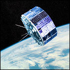
 The recently-rechristened Environmental Sciences Service Administration launches, with the help of NASA, ESSA-9, the latest in a constellation of weather satellites. ESSA-9 is the last weather satellite to carry the ESSA designation, as the government reorganizes ESSA into a new agency, NOAA, the following year. ESSA-9 remains in service until
 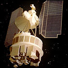 NASA launches the Nimbus 3 satellite, designed to observe weather patterns from orbit and test new weather and climate detection technologies. Nimbus 3 is the first Earth-orbiting spacecraft to test the SNAP-19 radioisotope thermoelectric generator system; devices similar to the SNAP-19 will become the primary power source for later deep space and outer solar system interplanetary missions. Nimbus 3 loses attitude control in
 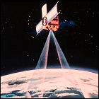 NASA and ESSA launch the ITOS satellite, also known as TIROS-M, a next-generation weather satellite intended to take over from the constellation of short-lived ESSA weather satellites. With a configuration that is, for the first time, significantly different from the TIROS/ESSA satellites, the TIROS-M design’s shakedown cruise is a short and bumpy one: after system failures force a shutdown of the satellite’s attitude control system, it is shut down in mid-
 The United States government reorganizes ESSA (the Environmental Science Services Administration) into NOAA or the National Oceanic & Atmospheric Administration, an agency responsible for weather prediction and research and for functions involving oceanic conditions, coastal fisheries, and then-current investigations of a potential Alaskan oil pipeline.
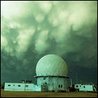 The National Severe Storms Laboratory‘s 10cm Doppler weather radar begins full-time experimental operation in Norman, Oklahoma, just in time for the region’s active severe weather season. A surplus Air Force radar left over from the Distant Early Warning radar network (also known as the DEW Line) is installed and housed in a facility that’s also made of military surplus parts. There is no real-time display at first: researchers and meteorologists store the Doppler radar’s observations on computer tape that has to be processed and printed months after the fact, and compared to archived records from the existing WSR-57 radar at Norman.
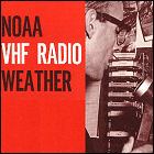 The National Weather Service’s NOAA Weather Radio system finally finds its purpose with the introduction of a piercing “warning tone” preceding emergency weather announcements such as severe weather warnings. Manufacturers of weather radio receivers (an item which hit the market in
  Dr. Tetsuya Theodore Fujita, a pioneering researcher in the formation and development of severe weather, proposes a scale for judging the intensity of tornadoes by the damage left behind. His five-point scale covers minimal tornadoes (F1) through storms capable of inflicting incredible damage (F5), with damage surveyed after a storm to determine the physical effects and the estimated wind speed needed to cause those effects. The Fujita Scale is adopted almost worldwide, remaining in widespread use by severe weather researchers and government agencies until it is supplanted by the more refined Enhanced Fujita Scale in the 1990s.
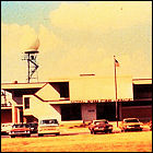 Students and seasoned weather researchers at the National Severe Storms Laboratory in Norman, Oklahoma embark on the Tornado Intercept Project (TIP), a concerted effort to gather film footage of developing or active tornadoes in an effort to study wind and debris patterns. Though believed by some to be of limited scientific value, TIP is the beginning of “storm chasing” and yields major breakthroughs in scientific understanding of the formation of tornadoes just one year later.
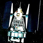 Originally named ERTS-1 (Earth Resource Technology Satellite), NASA’s Landsat satellite, based on the Nimbus weather satellites, is launched to begin constant observations of Earth’s land, air and oceans. Landsat 1’s tour of duty lasts just under six years, during which it discovers a previously unknown island – never before spotted from land or sea – off the northeastern Canadian coast. Landsat 1 remains in service through
 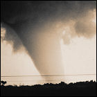 The National Severe Storms Laboratory in Norman, Oklahoma dispatches “storm chasers” to track, follow, and observe the behavior of storms in a predicted tornado outbreak. The chasers manage to document the complete development of a tornado in Union City, Oklahoma on film and on an experimental Doppler radar system; for the first time, large-scale cloud rotation at high altitude is observed on radar prior to the appearance of a funnel cloud, a key discovery in tornado prediction. This phenomenon, called the Tornadic Vortex Signature, is a precursor to virtually every radar-detected tornado.
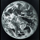 The first in a new generation of weather satellites operating in geosynchronous orbit for the National Oceanic & Atmospheric Administration, GOES-1, is launched from Cape Canaveral. An acronym for Geostationary Operational Environmental Satellite, GOES-1 is positioned over the Indian Ocean, where it is expected to become but the first in a constellation of weather satellites monitoring Earth’s atmosphere in both visible and infrared light. In
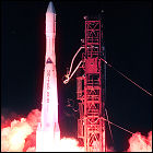
 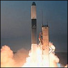 The second in a new generation of geosynchronous weather satellites is launched for the National Oceanic & Atmospheric Administration, GOES-2. An acronym for Geostationary Operational Environmental Satellite, GOES-2 is initially positioned at a point over 60 degrees west longitude on Earth, though it will be repositioned several times in its career as a weather satellite. In 1993, it will cease weather monitoring operations and will act chiefly as a communications satellite serving islands in the Pacific Ocean, as well as manned research facilities in Antarctica. GOES-2 will serve that function through 2001.
 British glaciologist John H. Mercer publishes a
  NOAA’s GOES-3 Geostationary Operational Environmental Satellite is launched from Cape Canaveral into a geosynchronous orbit over the Indian Ocean, replacing the first operational GOES satellite, GOES-1. GOES-3 will serve as a working weather satellite for over a decade, ultimately decommissioned from that role in 1989 and then serving as a communications satellite for the Pacific Ocean region and Antarctica, a role it continues to fill over 35 years later.
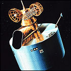 NOAA’s GOES-4 Geostationary Operational Environmental Satellite is launched from Cape Canaveral into a geosynchronous orbit over 98 degrees west longitude on Earth, a position which will change several times over GOES-4’s career until 1988, allowing it to monitor weather over the continental United States and Europe. In 1988, GOES-4 will become the first satellite to be boosted into a “graveyard” parking orbit using its remaining propellant, leaving it intact in a higher-than-geostationary orbit to avoid collisions with operational satellites.
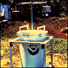 Researchers and storm chasers from the National Weather Service’s Severe Storms Laboratory in Norman, Oklahoma make the first field deployment of the 300-pound TOtable Tornado Observatory (TOTO) instrument package, a modified oil drum filled with meteorological instrumentation which is intended to be placed directly into the path of an oncoming tornado. The first deployment, in north Texas, yields no data – no tornado forms for TOTO to study. Over the next five years, despite several “close calls”, TOTO is never successfully placed in the direct path of a tornado. The TOTO program is discontinued in 1987.