
A hundred years ago today, the most powerful volcanic eruption of the 20th century took place on the Alaskan peninsula. Actually, it was probably the biggest eruption for a hundred years either side of June 6th, 1912. And what did it leave?
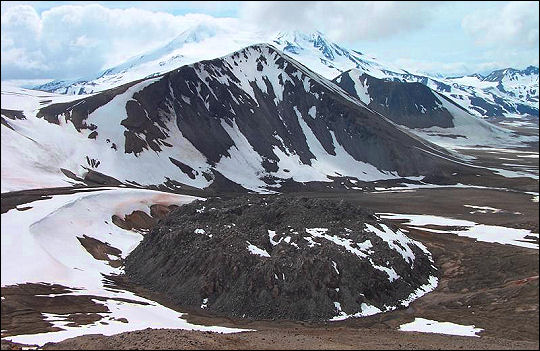
Photo: Pavel Izbekov, Alaska Volcano Observatory / University of Alaska Fairbanks, Geophysical Institute
A molehill instead of a mountain.
Now, actually, that’s no molehill. The Novarupta lava dome is a little over 1300 feet in diameter, and a little over 200 feet tall. It’s a plug over the throat of a volcano that erupted so powerfully that it blasted itself right off the map. (Need proof? Look at the sharply defined face of the ridge in the immediate background: it was pretty much bisected by the eruption.)
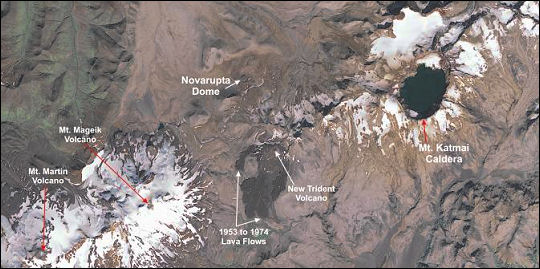
The eruption in question was what scientists probably refer to (most likely during off hours) as a “real humdinger.” The eruption was pretty hardcore: Novarupta’s plumbing was connected to neighboring Mt. Katmai, which was a full mountain with a peak at the time; Novarupta erupted its own supply of magma and then proceeded to erupt the magma stored under Katmai, causing Katmai to collapse in on itself. Katmai doesn’t have a peak anymore; it has a caldera with a crater lake. Oh, and Katmai is a little over six miles away from Novarupta. Katmai’s collapse had geologists thinking that it had erupted in 1912; volcanology was an emerging science at the time, and it wasn’t until the 1950s that the pieces of the puzzle were put together: the debris flows emanated from Novarupta, not from Katmai.
In Kodiak, Alaska, over a foot of ash fell, causing widespread roof collapse. Refugee camps had to be set up for the occupants of the many buildings that suddenly no longer provided adequate shelter from the elements. Within three days, it was raining ash in Seattle. Ten days later, ash from Novarupta reached Africa. When National Geographic researchers visited four years later, the valley created by the immense debris flow was still steaming – so much so that they called it the Valley of Ten Thousand Smokes. For years, the ground was still hot enough to boil water.
All that ash is a big deal. Remember the big air traffic tangle from the Icelandic volcano Eyjafjallajökull (or, as I’ve always called it, Eunice) in 2010? Imagine grounding most air traffic in the continental US and Canada.
It should come as no surprise that the Alaska Volcano Observatory, a project run jointly by the US Geological Survey and the University of Alaska, monitors the crap out of this particular molehill.
To put this in perspective with other 20th century eruptions that most people are more familiar with, as well as some well-known historical volcanic events, Judy Fierstein of the USGS prepared this graphic for a recent series of lectures on the Novarupta/Katmai anniversary:
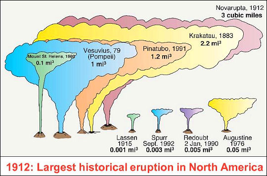
Three times more material was erupted at Novarupta than during the famous eruption of Vesuvius that destroyed the city of Pompeii. And Mt. St. Helens? A mere firecracker.
Debris from the eruption dammed the Katmai River, but three years later, runoff from melting snow burst that dam, putting most of the area under about ten feet of water for an extended period of time.
It’s just as well that the eruption alone forced nearby settlements to clear out in 1912. If the residents had stuck it out, the flood of 1915 might well have killed them. The displaced settlers were relocated twice; their final destination became what is now known as Perryville, Alaska. The nearest “modern” city at the time, Kodiak, suffered severe damage to its infrastructure, particularly its water supply. Local flora, fauna and fish were goners.
Alaska isn’t exactly densely populated today, but the increase in population over the past century would make this a National Emergency even before the ash started clogging the airways. This area is now federally protected as part of Katmai National Park, bordering the Becharof National Wildlife Refuge. From 1912-1915, the only thing preventing it from becoming the site of massive loss of life was the scarcity of human settlement.
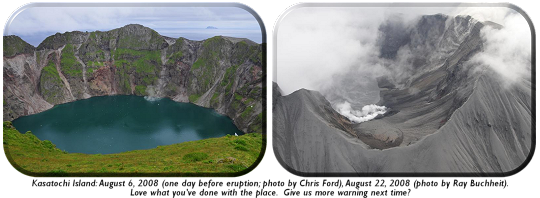
Will it blow again? That’s hard to say (and, as usual, anyone who says they can predict earthquakes or volcanic eruptions is full of something even less savory than molten lava). Both Katmai and Novarupta are closely monitored by the AVO for any further signs of activity, along with a great many other volcanoes in Alaska and the Aleutian Islands (a territory that accounts for over 80% of the volcanoes, active or inactive, in the United States). In many cases, due to limited resources, AVO has to make do with the sensors it has deployed to monitor neatby volcanoes as well, but that’s a poor substitute for eyes on the ground or, at the very least, a more elaborate, specific network of sensing equipment on the ground. (One good example is Kasatochi Island, which last erupted in August 2008; a series of pre-eruption quake activity was picked up by sensors on neighboring Great Sitkin Volcano, but there were some eyes on the ground: two U.S. Fish & Wildlife Service scientists were stationed at a hut on Kasatochi, where they’d been airlifted since the volcano was thought to be dormant. They had to radio the mainland for evacuation from the island, which blew its top hours after they left. The eruption left no trace of the hut.)
As thin as the AVO’s available resources are, there are those who’d like to force them to cut back even further. In 2009, tasked with issuing the Republican response to President Obama’s State of the Union address, Louisiana Governor Bobby Jindal mocked the fact that stimulus money was earmarked for improving volcano monitoring.
About six weeks later, Mt. Redoubt, within shouting (and ashfall) distance of Anchorange (and, for the record, Wasilla), woke up and laughed.
No doubt, Governor Jindal would’ve been screaming bloody murder if the National Hurricane Center’s funding was cut, leaving post-Katrina Louisiana without any warning system. But of course, it’s all the rage these days to use the benefits of scientific research (computers, cell phones, GPS, digital cameras, tablets, MP3 players) while simultaneously claiming that science somehow “lies” across-the-board. (Do a few scientists lie? Probably – they’re human, but the bad apples are not in the majority. Check their numbers: the numbers don’t lie. This is why you have peer review.)
The population of the Pacific Northwest – most likely to be severely affected by another volcanic event of his magnitude – has increased steadily since 100 years ago today, and so has the prevalence of technology and infrastructure that’s susceptible to ashfall (car air filters, air-breathing aircraft engines, water supplies, take your pick). The next Novarupta – even though it probably won’t erupt from Novarupta itself – would be felt much more widely than in 1912.
All the more reason to keep the volcano monitoring infrastructure in good shape. Volcanoes are apolitical. A volcanic landslide doesn’t pick who or what it overruns, and ash doesn’t carefully select its landing site. Putting scientific instruments and experts in place to mitigate the damaging effects of nature is common sense; bickering about it until it’s suddenly a crisis without a plan isn’t.
The USGS and the University of Alaska have published a very comprehensive report on the eruption, and scientific findings from 1912 through today, here. You can go download it for free.


+ There are no comments
Add yours